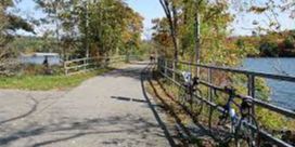
Putnam County Trailway
The old New York Central rail line that ran from the Bronx to northern bedroom communities in Westchester and Putnam Counties carried commuters during the workweek, but on the weekends tourists heading to resorts and vacation homes in northern Putnam County filled those passenger seats. Today, the Putnam Trailway follows nearly 12 miles of that rail-line route to popular lakes in the woodsy hills around Carmel and Brewster.
The trail follows a corridor created in the 1880s by several railroad companies that eventually became the New York and Putnam Railroad in 1894—soon known as the Old Put. By 1913, it had become the Putnam Division of the New York Central Railroad, providing passenger service until 1958. The railroad continued hauling freight into the 1980s. In the wake of the line’s demise, four trails have opened along the 45-mile route. South to north they are Old Putnam Trail, South County Trailway, North County Trailway, and Putnam Trailway.
The paved trail—part of New York’s 750-mile Empire State Trail—starts at the old passenger depot site in Baldwin Place. Although the Putnam Trailway slopes downhill toward Brewster from here, there are a few short, steep climbs in the wooded watersheds surrounding lakes and reservoirs in the north.
The trail follows US 6 through residential and commercial areas and arrives in Mahopac in about 2.2 miles at an old railway depot that’s now an American Legion Hall. The hamlet encircles the 500-acre Lake Mahopac. Though the shoreline is privately owned, marinas rent boats for those who want to fish.
Crossing Croton Falls Road on the way out of Mahopac, the trail enters a hardwood forest that surrounds the path nearly to Brewster. In a mile, you’ll pass the south shore of Lake Casse; a beach is at the lake’s north end.
Traveling through the woods another 3 miles, you’ll meet up again with US 6 on the shores of Lake Gleneida. These hills shelter numerous lakes and reservoirs chosen by New York City for its water supply. That’s why swimming is prohibited in this lake, but boating, fishing, and ice fishing are allowed. Leaving the lake, the trail dips to cross a creek and in 2 miles crosses a 1,000-foot causeway across Middle Branch Reservoir.
The trail ends at Putnam Avenue in Brewster, but work is underway for a 0.5-mile, five-span pedestrian bridge across a road, rail yard, brook, and swampy area to join the Maybrook Trailway in late 2019. The Maybrook stretches another 23 miles along the Empire State Trail, connecting to the William R. Steinhaus Dutchess Rail Trail in Hopewell Junction.

Putnam County Trailway
Parks & Recreation